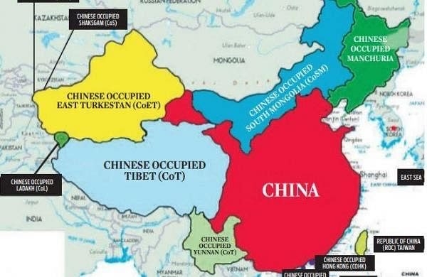
Former army chief Manoj Naravane says 'someone got map of China as it really is'
13 Sep 2023 11:23:59
New Delhi, Sept 13: In a significant development, former Chief of Army Staff General Manoj Naravane (Retd) has shared a map of China, which according to him is the actual geographical representation of the nation. Notably, the shared map is much smaller than it claims.

The new map, showing the territories that were occupied by China, was going viral for a while and was also Naravane's post on Tuesday (September 12). "Finally someone has got the map of China as it really is," he wrote on X without revealing the source of the photo.
What is the map?
The map shows regions as they used to be decades ago. On the western side, it shows Tibet and East Turkestan (former independent states). On the map, it says Chinese occupied East Turkestan (CoET) and Chinese Occupied Tibet (CoT).
The map also shows Chinese-occupied south Mongolia, Yunnan, Manchuria, and the Chinese-occupied India's Ladakh. Chinese occupations over the years have changed the map, which is still contested.
It highlights the fact that India and China never shared a border before the 1950s - the annexation of Tibet by the People's Liberation Army in 1950, just a year after the People's Republic of China was established by Mao Zedong in 1949.
In the present scenario, India and China do share a border, but the conflicts persist. A document by the Indian government noted that the nation shares 3488 km of border with China that runs along the States of Jammu & Kashmir, Himachal Pradesh, Uttarakhand, Sikkim and Arunachal Pradesh. The document states that the "border is not fully demarcated and the process of clarifying and confirming the Line of Actual Control is in progress".
China map row
This map comes against the backdrop amid the Chinese map controversy as Bejing claimed regions beyond its border by officially releasing the 2023 edition of its so-called "standard map". The map shows certain areas, including parts of India's Arunachal Pradesh, Jammu and Kashmir, Aksai Chin region, Taiwan and some regions of the disputed South China Sea, as part of China.
India strongly protested the release of the controversial map, saying "we reject these claims as they have no basis. Such steps by the Chinese side only complicate the resolution of the boundary question".
