NB Twitter Scan | Operation Meghdoot: When the Indian army destroyed Pakistan's impending Operation Ababeel by securing the 'highest battlefield in the world'
13 Apr 2023 12:49:29
The following article is based on twitter thread by
@HistorifyToday
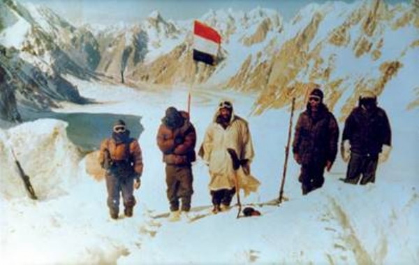
In the early hours of April 13, 1984, a group of soldiers from the Indian Army's 102 Infantry Brigade boarded helicopters and took off towards the Siachen Glacier. The mission, codenamed Operation Meghdoot.
Operation Meghdoot, is an historic even which was started after Pakistan violated Shimla Agreement, and ended by Indian Army by securing strategically important Siachen Glacier which is known as highest battlefield in the world. It is a saga of unmatched bravery, heroism, courage and sacrifice on the world's highest and coldest battlefield.

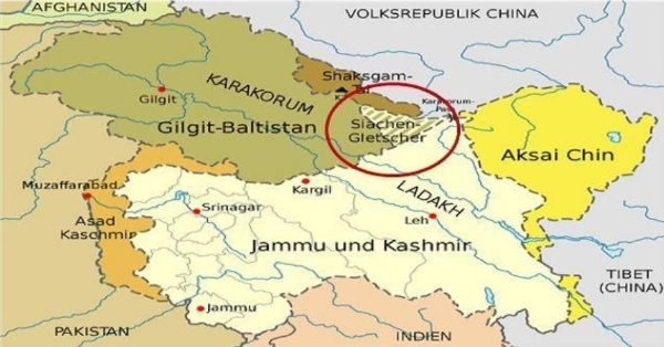
The story of Siachen didn’t start in 1983. Siachen, which ironically means “Rose Garden” in local Balti language, located in Eastern Karakoram, it is 75 km long, and is the highest battlefield in the world. The 110 KM line beyond NJ9842 is called the Actual Position Ground Line.
The genesis of the Siachen conflict lay in Partition, after the first Indo-Pak war, the 2 nations agreed on the ceasefire line. The problem is that the line was not demarcated beyond a point NJ9842, as it was an inhospitable area.
The agreement simply said thatthe beyond NJ9842, the line would run North of the glaciers, which included Siachen, Rimo and Baltoro. It was believed that no military operations would take place there at those inhospitable areas, and both sides, did not care much about it.

After the ’71 war', as per the 1972 Shimla Agreement, this ceasefire line became the LOC, and once again the Siachen glacier was left out. As it was considered an inhospitable area, no attempt was made to enforce jurisdiction over it.
And this was a blunder by the Indian establishment, as Pakistan had already begun making changes in it’s maps to include Siachen within it’s ambit. Between 1964-72, a series of maps by Pak, showed Siachen as part of it, and this was accepted globally too. While India contended that the Pakistan’s territorial limits lay only till Saltoro Ridge, they contended that territory was till Karkoram.For a large part of the 70’s and early 80s, there were rival mountaineering expeditions, to climb the peaks located in the Siachen region.
Col Narendra Kumar led one of the first Indian expeditions to Siachen in 1978, undertaking a 24,631 foot ascent to Teram Kangri. Nicknamed “Bull”he also pointed out that while Pakistan allowed mountaineers from all over, India denied access to it’s own soldiers there.
_202304131257582892_H@@IGHT_168_W@@IDTH_300.jpg)
The trigger was a German mountaineering map, which Narendra Kumar showed to Lt. Gen Chibber, then Dir of Military Ops, in which the whole of Siachen and surrounding areas was shown as part of POK( Pakistan Occupied Kashmir). At one stage, during Kumar’s 1978 expedition to Siachen, a Pakistani Sabre jet flew right over his team, which is when he recommended that India establish a post there. However Army HQ rejected his proposal saying it was impractical to set up in such conditions.
The fact is way till 1978, Indian establishment, did not consider Siachen as much of significance, being an inhospitable area. While Pakistan all this time, was allowing international mountaineers there, and claiming it in it’s maps.
However when the Pakistani Army sent a warning note in 1982, asking India to keep out of Siachen, Chibber who was then the Northern Army commander, countered back, and patrols were set up in that region.
By the end of 1983, it was obvious to India that Pakistan was moving it’s troops to Siachen to occupy it. Intelligence reports had shown large scale troop movement by Pakis, as also purchase of high altitude gear in large numbers from Europe.
The trigger to Operation Meghdoot was the Pakistani Govt allowing a Japanese expedition on Rimo I, one of the important peaks in 1984. Overlooking the northwestern part of Aksai Chin, that is occupied by China, Rimo I, was a strategically important peak in Siachen.
Indian army believed that Rimo I expedition cud pave way for a trade route between China and Pakistan, and prove to be of strategic use.Indian Army decided to deploy from Northern Ladakh, most of the troops were already acclimatized to the conditions.
A rigorous training expedition in Antarctica in 1982, had acclimatized the Indian troops to the conditions in Siachen. At that time, when Indian Army already got intelligence reports that Pakistan might attack on April 17, they decided to carry out pre-emptive strike.
India then decided to act swiftly in order to prevent Pakistan from occupying the Siachen glacier. The move was approved by Indira Gandhi.The Indian Army operation on Siachen, was named after the character in Kalidasa’s play Meghdootam.
Brig Vijay Channa, was given the task of occupying Saltoro Ridge, in Sector 26. He choose April 13, as it was Baisakhi Day, and the Pakistani’s believed Indian Army would not launch an attack on such a date. Lt.Gen. Prem Nath Hoon, GOC, 15 Corp, in Srinagar,led Operation Meghdoot on Siachen, on April 13,1984. Indian Air Force began the airlift of troops and supplies through the aircraft Il-76, An-12 and An-32 to the high altitude airfields.
April 13, 1984 at 5:30 AM, the first Cheetah helicopter took off carrying Capt Sanjay Kulkarni, by noon, 17 such sorties were undertaken and 29 soldiers were airdropped at Billafond La. Mi-7,8.
HAL Chetak helicopters were used to transport the troops to the eastern part of Siachen. Lt.Col D.K.Khanna, led a full battalion of Kumaon Regiment and some Ladakh Scouts units initially along the Zozila Pass.
Major R.S.Sandhu established first position on Siachen, Capt Sanjay Kulkarni secured Bilafond La pass.Capt P.V.Yadav, led the remaining deployment units to capture the Saltoro Ridge, and by April 13, Indian troops had taken up most area.
The pre-emptive assault on Siachen ensured that when Pakistan attacked, all the major passes in Siachen were occupied by Indian troops.Indian troops were in full control of Sia La, Gyond La and Bilafond La, the 3 major mountain passes, when the Pakistani troops attacked.
Operation Meghdoot ensured that India captured nearly 2600 sq km of territory in Siachen, as well giving a tactical advantage.
After loosing misrebly from indian army, the Pakistan tried to recapture Siachen in 1987 and 1989, however, both times they were beaten back.Pervez Musharaf, who was Brig-Gen in 1987, led the first attempt to recapture Siachen, managed to capture some points, but was pushed back.
Bana Singh, led an assault on a Pakistani post located at a height of 6500 metres, trekking through an absolutely hazardous route. The Pakistani post at a height of 6500 metres in Siachen, was considered a fortress, with 457 metres high ice walls on either side.Leading a team of 162 soldiers, Bana Singh, launched a frontal attack on the Pakistani post, and captured it after fierce fighting.
The attempt by Pakistan in 1987 to recapture Siachen, would be noted for the bravery of Subedar Bana Singh who got a Param Vir Chakra. The attack on the Pakistani post in 1987 by Bana Singh was codenamed Operation Rajiv.
If the strategically important Siachen Glacier is now part of Indian territory, it is thanks to Operation Meghdoot, and heroes like Col Narendra “Bull” Kumar, Subedar Bana Singh, Capt Sanjay Kulkarni, We owe a lot to them.
