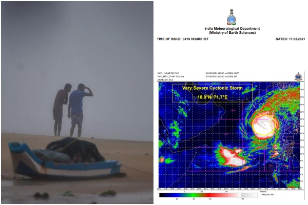
Cyclone Tauktae gets ‘extremely severe’, likely to hit Gujarat coast tonight
17 May 2021 10:35:17
Mumbai, May 17: Very severe Cyclonic Storm Tauktae has intensified into an extremely severe cyclonic storm centered about 160 km west-southwest of Mumbai, 290 km south-southeast of Veraval (Gujarat), 250 km south-southeast of Diu and 840 km south-southeast of Karachi. It presently has a wind speed of 180 to 190 kmph gusting to 210 kmph, according to India Meteorological Department (IMD).

It is very likely to move north-northwestwards and reach Gujarat coast Monday evening between 2000 – 2300 hrs IST and cross Gujarat coast between Porbandar & Mahuva (Bhavnagar district) the same evening as a very severe cyclonic storm with a maximum sustained wind speed 155-165 kmph gusting to 185 kmph. Large-scale damage is expected over Porbandar, Amreli Junagarh, Gir Somnath, Botad, Bhavnagar and coastal areas of Ahmedabad.
ALSO READ- 'निराशा का कोई कारण नहीं है, हम जीतेंगे'- 10 important highlights from Dr Mohan Bhagwat's #PositivityUnlimited speech
There is likely to be total destruction of thatched houses and extensive damage to kutcha houses; some damage to pucca houses; potential threat from flying objects; bending or uprooting of power and communication poles; major damage to roads; flooding of escape routes; minor disruption of railways; overhead power lines and signalling systems; widespread damage to salt pans and standing crops; blowing down of bushy trees; small boats, country crafts may get detached from moorings; visibility may be severely affected.
Some damage is also expected over Devbhoomi Dwarka, Kutch, Jamnagar, Rajkot, Morbi, Valsad, Surat, Vadodara, Bharuch, Navsari and Anand districts. IMD has recommended evacuation of people from vulnerable areas, total suspension of fishing operations, judicious regulation of rail and road traffic, people in affected areas to remain indoors, movement in motor boats and small ships could be unsafe.
“Tauktae will intensify further while on its track and cross the Gujarat coast with a speed of 155 to 165 kmph gusting to 185 kmph. We are not expecting it to become a super cyclone but it is a big and intense system,” said Sunitha Devi, in charge of cyclones at IMD. Light to moderate rainfall is likely at most places with heavy to very heavy falls at a few places and extremely heavy rain (over 20 cm) at isolated places over south Konkan, north Konkan and Goa and adjoining Ghat areas on Sunday and Monday and heavy to very heavy falls at isolated places on Monday.
Over Gujarat, light to moderate rainfall is likely to commence over coastal districts of Saurashtra from Sunday afternoon, with heavy to very heavy falls at isolated places over Saurashtra, Kutch, Diu and southern most Gujarat region with extremely heavy falls at isolated places on Monday and heavy to very heavy falls at a few places over Saurashtra, Kutch, Diu and south Gujarat region with extremely heavy falls (≥ 20 cm) at isolated places on Tuesday. Extremely heavy rainfall is also likely over south Rajasthan on Tuesday.
.
.
