Do we really understand basic river ecosystem before pushing up development project?
Total Views |
New Delhi, September 28: Half of the country experienced devastating flood this rainy season. Along with the flood of water, there occurred an equally massive flood of discussions and debates. Was this disaster natural or man-made? Could the intensity of the flood and damage have been lowered? Did only heavy rains cause this disaster?
In order to get the satisfactory answers to all these questions, we need to understand the basics of river ecosystem. Solution of any disaster-related problem needs basic ecological literacy which is what lacking today.
This article is an attempt to throw some light on the basics of river ecosystem so that, to some extent, we will get an idea why flood-like disasters are getting so much intense day by day!
When we talk about ‘river ecosystem’, we have to take into account the entire river basin which includes origin, tributaries, springs, floodplain, riparian zone, catchment area, etc. Many times, policy-makers or so-called ‘developers’ confine the concept of river mere as a water flowing through a channel. Lacking of holistic approach of seeing the river as the entire ‘river basin’ is a basic cause of likeliness of intensive disasters. Disasters are always natural; intensity of their consequences is man-made!
So, Let’s make a journey by a river, understanding it’s ecosystem step by step…
One third of the earth’s surface is occupied by water which is called as ‘hydrosphere’. Aquatic ecosystem is composed of ‘freshwater ecosystem’ and ‘marine ecosystem’. Freshwater ecosystem is of two types – ‘lentic ecosystem’ (ecosystem of stagnant water e.g. lakes, ponds, etc.) and ‘lotic ecosystem’ (ecosystem of flowing water e.g. river, stream, spring, etc.). Thus, river is a part of ‘lotic ecosystem’. It has all the characteristics which a lotic ecosystem possesses.
Origin of a river:
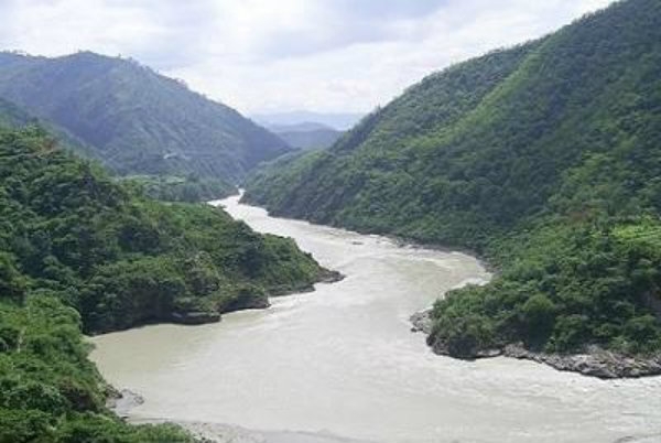
Even a school student knows that river originates in mountains. However, we can’t pinpoint exact place as the origin of a river. When rain pours on mountains, hundreds of small flows are created through the wedges between rocks. These small springs further meet at some point and create a bigger stream. When Many of such streams meet at some further point, they create a large flow, which we call as ‘river’.
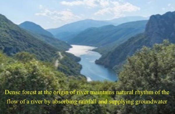
‘Dense forest’ is a big characteristic of the region of the origin of a river. In fact, it’s a need of that region. Forest absorbs much of the rainfall, thereby preventing water to directly flow into the river. On the other hand, water absorbed by forests during rainy season is released in dry season which keeps the flow of a river intact. Hence, higher the deforestation at the origin, more sudden will be the increase in water level of the river and higher will be the probability and intensity of flood, and also, higher will be the probability of draught during dry season. Hence maintaining dense forest in mountain areas becomes essential for maintaining natural rhythm of the flow of a river.
Godavari, Krishna and Cauvery; along with their hundreds of tributaries, are the three main rivers supplying water to entire south India. All these rivers originate in western Ghats. Thus, we can easily realize why saving of the forest in the Western Ghats is so crucial and why the Gadgil Committee Report is worth considering!
Flow and Flood:
These two ‘F’s are two important natural functions of a river. (Yes! ‘Flood’ is also an important natural function of a river. We look at it as ‘disaster’ because human being have made the settlements in floodplains) Erosion, transportation and deposition are the three main consequences that flow of a river brings about. The flow erodes the river bed in the mountain areas and eroded material (soil, minerals) is deposited in plains where the speed of a river is low. Water also carries sediments. Size and mass of sediments determines its speed of moving along with the water. Therefore, we see big rocks towards the origin of river, small rocks in the middle area and sand in the mouth area of the river.
These sediments play a big role in river ecosystem. Standing as hurdles in the flow, they lead to an uneven flow of water, form natural sprinkles which lead to good mixing of oxygen into the water. Good level of ‘dissolved oxygen’ is an essential factor of river ecosystem which keeps river naturally clean. Slits in sediments form good habitat for aquatic vegetation, insects and reptiles.
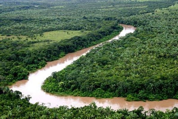
‘Meandering flow’ is another unique characteristic of a river. It is the result of sequential erosion and deposition on opposite sides of a river. Forceful water erodes the concave bank of river while the eroded material is deposited to the bank where it is convex in shape. When this happens for some thousands of years, it creates meandering channel, which increases the length of a river, keeping the width intact. Meanders are the natural speed controllers of a river.
Intervention in upper riparian area directly affects the lower riparian region. For example, construction of dam in upper riparian area reduces the supply of water, silt and nutrient-rich soil. Pollution in upper riparian area is faced by the people in the lower riparian area.
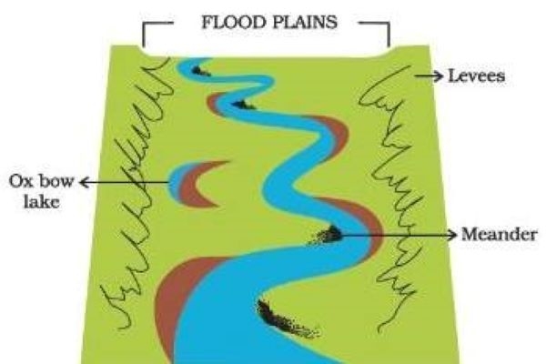
As mentioned above, ‘flood’ is also a natural function of a river. An imaginary line which indicates the highest horizontal reach of flood occurring once in 25 years is called as ‘Blue Line’ whereas the line denoting the reach of flood occurring once in 100 years is called as ‘Red Line’. Not make any construction or other developmental activity is not only a government’s law, but an environmental norm as well. Breaking government’s rules is quite simple, but how horrible can be the consequences of going against nature has been very well experienced in the last month’s flood. Floodplain is the best place for agriculture as flood supplies nutrient-rich soil to the floodplain area.
Throughout its journey, many small streams join the river which act as natural flood-controllers. When water-level rises, much of the water is accommodated in these streams ultimately leading to low intensity of flood. We have destroyed most of the natural streams for development projects, filing them with debris and destroyed the natural flood-controlling system. The Ambil stream in Pune, which was one of the main water resources of the city, has today turned into Bajirao road.
At its mouth, a river creates a distinguished ecosystem which is characterized by dominance of mangrove forest. Mouth of a river is the battleground of river and sea where both fight with each other with immense force. High speed of a river prevents the sea to come inside and protects the agricultural land from becoming saline. However, in recent times, researchers have found that the sea water has come inside the Krishna riverbed to about 50kms. This has caused by artificially slowing down the speed of a river by carelessly constructing dams.
Biodiversity:
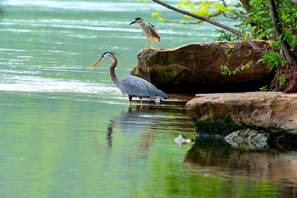
River is a home for many big and small habitats. Biodiversity is dense in the areas where the flow of a river is comparatively slow. A river accommodates various types of algae, phytoplankton, moss, grasses, microbes, fish, crocodiles, water-birds, turtles, etc. through which food chain and energy-flow is maintained. Almost 250 species of fish are found in river Ganga itself! Well-known scientist Dr. V. D. Vartak had conducted a biodiversity study of Pune’s Mutha river in 1954 in which he had noted down around 400 species of plants. Biodiversity in river is highly adapted to the speed of the flow. In most of the cases, construction of a dam disturbs the natural flowing speed of river which adversely affects biodiversity.
What kind of flora and fauna is found in river determines whether the river is clean or not. The presence of phytoplankton, moss, waterbeetles, dragonflayers, tadpoles, local fish species, birds like kingfisher or jacana indicate the clean status of a river. On the contrary, growth of water hyacinth, crows, pond heron, kites is an indicator of a polluted river.
Waterfall is created when a river collapses on hillock. It creates vertical wetland which is a favourable habitat for grasses like trypogon; birds like Malbar Whistling Thrush, etc. Most of the species are endemic to such habitats.
Riparian Forest:
This is a very important component of river ecosystem. We see a significantly dense vegetation along both sides of a river which comprise trees like Umbar, Valunj, Karanj, Arjun, Peeple, Banyan, Taman, Shindi, Sawar, Shirish, etc. and various types of grasses. This riparian forest plays a big role as a natural flood controller by absorbing water and preventing it from directly infiltrating the nearby area. The forest enhances the groundwater recharge and also, to a great extent, prevents erosion of the riverbanks. It filters the water which comes from the nearby farmlands and residential area into the river.
Creating habitat for various animal species, riparian forest supports the overall river ecosystem to a large extent. Historical evidences show that Peshve (Rulars in Pune in 18th century) used to go on riverbanks of Mula-Mutha river for hunting. This reference shows how dense the riparian forests must have been some hundred years ago! The shadow of the trees growing on riverbanks controls the temperature of the river-water. Leaf-fall of the riparian trees in river also plays a big role in ecosystem by supplying organic matter to primary aquatic consumers. Modern interventions such as channelization of rivers, beautification of riverbanks are posing big threat to riparian vegetation.
Relation of Man with River:
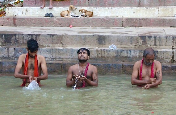
Indian people look at rivers from a sense of motherhood. In Indian culture, a river is considered as our mother as it takes care of human beings just as a mother takes care of her children. Bathing in rivers has been considered holy since ancient times.
In Rigveda, there is a chapter named ‘Nadi Sukta’ which mentions holy Indian rivers like Ganga, Yamuna, Saraswati, Shutudri, Vipasha, Parushni, Asikni, Maridvridha, Vitasta, Arjikiya, Sushoma, Trisama, Sindhu, Gomati. Saaraswati was one of the most respected rivers during Aryan period. Maharshi Vyasa called rivers as ‘Mothers of Universe’. In Saptasindhu region, there were born Vedic literature. ‘Yadnya’ culture flourished in the Ganga-Yamuna region. India’s north-south divider Narmada incubated many tribal cultures. The splendid kingdom of Satvahan spread across Godavari which is considered as the Ganga of Maharashtra. Cauvery is as sacred in South India as Ganga in North India. Kingdoms of Chol, Pallav and Dravid culture flourished on the banks of Cauvery. The large empire of Vijaynagar, which was the biggest follower of Vedic culture took the shelter of river Tungabhadra. Thus, In India, one river represents one unique culture!
In previous times, Man used to go in or near a river for the sake of bath, worship or fetching water. Now, due to easy availability of water at home through tap, direct connection between man and river has not remained anymore. Man also has lost the emotional attachment with rivers which existed significantly once upon a time. We are carelessly destroying this precious ecosystem in nature, which provides us enormous ecological services. Do we really understand basic river ecosystem before using it as a natural resource? Do we consider the carrying capacity of a river before constructing dams, making constructions on riverbanks? Because of being reluctant about consequences, we see intensified disasters today.
Eventually, all this comes to human consumerism. More we save the electricity and water, less number of dams will be required and the natural ecosystem of river will be kept intact. Simpler the structure of houses, there will be less riverbed sand mining. Lesser we use the chemicals like soap, toothpaste, detergent, floor-cleaner, toilet-cleaner; lower will be the pollution of the river.
As rise and set is the religion of the sun, whistling is the religion of birds, blowing is the religion of wind; flowing is the religion of a river
…And, Letting the rivers flow is the religion of human being!
